

Route 66 is the historic Chicago to Los Angeles highway, officially designated on 11 November 1926 and celebrating its centenary in 2026. It runs about 2,448 miles (3,940 km) through 8 states - Illinois, Missouri, Kansas, Oklahoma, Texas, New Mexico, Arizona and California - from the "Begin" sign in downtown Chicago to the Santa Monica Pier. The US highway itself was retired in 1985, but roughly 85 percent of the old road is still drivable as state-signed Historic Route 66, and this guide gives you the map, the stops worth your time, the days you need, and the costs and myths to plan around.
The Route 66 map, state by state
Read the map westbound, the direction most people drive it: out of Chicago across the Illinois prairie, through Missouri and a 13-mile corner of Kansas, then the long Oklahoma and Texas Panhandle run, the high desert of New Mexico and Arizona, and down through the Mojave to the Pacific. State mileages below are the rounded published figures for the historic alignment - they are a planning guide, not a survey.
| State | Distance | Signature stops |
|---|---|---|
| Illinois | 301 mi / 485 km | Chicago Begin sign, Gemini Giant, Pontiac museum |
| Missouri | 317 mi / 510 km | Chain of Rocks Bridge, Meramec Caverns, Springfield |
| Kansas | 13 mi / 21 km | Galena's Cars on the Route, Rainbow Bridge |
| Oklahoma | 432 mi / 695 km | Blue Whale of Catoosa, Arcadia Round Barn, POPS |
| Texas | 186 mi / 299 km | Cadillac Ranch, Midpoint Cafe, U-Drop Inn |
| New Mexico | 487 mi / 784 km | Blue Swallow Motel, Blue Hole, Albuquerque's Central Avenue |
| Arizona | 401 mi / 645 km | Winslow's corner, Seligman, Oatman's burros |
| California | 314 mi / 505 km | Roy's at Amboy, Wigwam Motel, Santa Monica Pier |
Where does Route 66 start and end?
It starts in downtown Chicago and ends, ceremonially, at the Santa Monica Pier - with two honest footnotes. The 1926 eastern terminus was Jackson Boulevard at Michigan Avenue; today's westbound "Begin" sign stands a block away on Adams Street, because Jackson later became one-way. For the centenary, Chicago also designated Navy Pier as the symbolic 2026 starting point, creating a "pier to pier" pairing - the historic sign has not moved. At the other end, the 1926 terminus was actually 7th and Broadway in downtown Los Angeles; the road was extended to Santa Monica in the mid-1930s, and the pier's famous "End of the Trail" sign only dates to 2009. Drive to the pier for the photo everyone takes, knowing the paperwork ended in LA.
How long is Route 66, and how much can you still drive?
About 2,448 miles (3,940 km) on the commonly published original alignment - alignments shifted over the road's life (dropping the Santa Fe loop alone cut roughly 100 miles from New Mexico), so treat any exact figure as approximate. The highway was decertified on 27 June 1985, which is why no US 66 shields exist today. The National Trust for Historic Preservation estimates about 85 percent of the original route remains drivable under other names and Historic Route 66 signage - but not as one continuous road: you stitch it together with frontage roads, state routes and short interstate hops. A bill to make it a National Historic Trail was introduced in Congress in September 2025 and had not been enacted as of October 2026, whatever some headlines imply.
A short, true history
Route 66 got its number by telegram: on 30 April 1926, Cyrus Avery and colleagues wired from Springfield, Missouri, proposing "66" after a dispute over the number 60 - which is why Springfield calls itself the road's birthplace. The US Highway System, US 66 included, was officially approved on 11 November 1926, the date the centenary counts from. The road then carried Dust Bowl families west in the 1930s (Steinbeck called it the Mother Road in The Grapes of Wrath), boomed with post-war tourism, and was slowly bypassed by interstates until decertification in 1985. The preservation movement started in Seligman, Arizona, where barber Angel Delgadillo founded the first Historic Route 66 association in 1987 - the model the other seven states followed.
Must-see stops in all 8 states
Illinois
Start with breakfast at Lou Mitchell's on Jackson Boulevard (serving since 1923; current hours are limited, so check before you go), photograph the Begin sign, then stop in Wilmington for the Gemini Giant - know that it moved in 2024: the Launching Pad diner is closed and the Giant now stands restored at South Island Park. Pontiac's Route 66 Hall of Fame and Museum is free and anchors a good mural walk. At the state line, the Old Chain of Rocks Bridge is walkers and cyclists only - you cross the Mississippi on foot, mid-river bend and all, you do not drive it.
Missouri
Springfield is the birthplace city and hosted the national centennial kickoff; give it an evening. In St Louis, the Gateway Arch is a worthwhile detour but is not a Route 66 structure (tram tickets start at $15) - do not let guides tell you otherwise. Meramec Caverns at Stanton, a cavern tour of about 80 minutes (adults $30.50 on the published tariff, closed for a winter stretch), is the classic Missouri cave stop the road grew up with.
Kansas
The whole state takes 13 miles and under an hour, and it punches above its length: Cars on the Route in Galena, a restored Kan-O-Tex station whose tow truck inspired Tow Mater in Pixar's Cars; the 1923 Rainbow Bridge near Baxter Springs, the last Marsh Arch bridge on the road; and the Old Riverton Store, trading since 1925, for the sandwich stop. Galena Days in June is the Kansas centenary anchor.
Oklahoma
Oklahoma holds the longest surviving stretches and the densest roadside Americana: the Blue Whale of Catoosa (free, photo only - the swimming days are over), Arcadia's 1898 Round Barn (free, volunteer-run) and POPS next door with its 66-foot soda bottle and 700-plus sodas, and the Oklahoma Route 66 Museum in Clinton for the state's official telling (admission figures in listings conflict, so check the Historical Society before you budget it). Totem Pole Park near Foyil is a short detour off the road, free, and worth it.
Texas
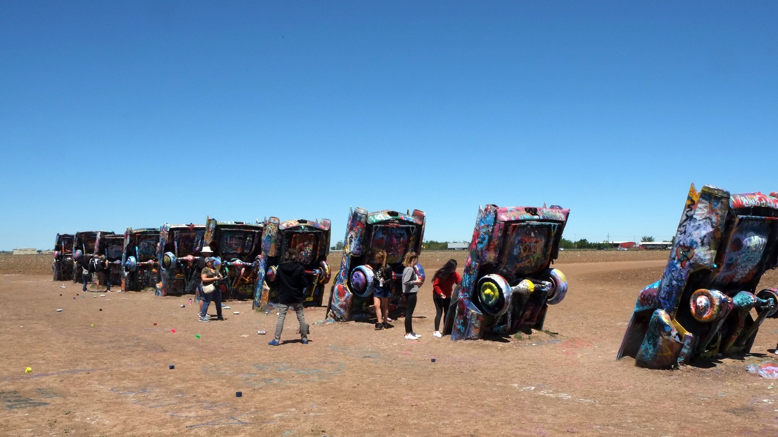
All 186 Texas miles cross the Panhandle. Cadillac Ranch outside Amarillo is free, open around the clock, and spray-painting the ten buried Cadillacs is not just allowed, it is the point - bring paint, and paint nothing else. At Adrian, the Midpoint sign reads 1,139 miles to Chicago and 1,139 to Los Angeles (a 1995 branding figure, not a 1926 measurement); the Midpoint Cafe beside it closes seasonally in winter. In Shamrock, the 1936 U-Drop Inn is an Art Deco jewel that now works as a visitor centre, not a cafe.
New Mexico
Tucumcari's Blue Swallow Motel (1939, garages beside the rooms, the "100% Refrigerated Air" neon) still takes guests - sample rates seen in October 2026 ran about $120-160, indicative only. Santa Rosa's Blue Hole is a deep artesian spring holding roughly 62°F (17°C) year-round, with a per-vehicle parking fee whose published figure varies, so check on arrival. Albuquerque gives you 18 miles of Central Avenue, the KiMo Theatre, and the El Rancho Hotel in Gallup at the state's west edge. One correction: the Musical Road near Tijeras has degraded and lost its signs - do not drive out expecting to hear it.
Arizona
Arizona holds the road's best driving: from Seligman, where the preservation movement began, Historic Route 66 runs 140-plus continuous miles through Hackberry (a memorabilia store, not a fuel stop) to Kingman - and there are no working gas stations on that stretch, so fill up in Seligman. Oatman's wild burros roam the main street daily; they are genuinely wild, so keep dogs back and do not feed them. Winslow's Standin' on the Corner park is a free photo stop built around the Eagles lyric. Kingman's Powerhouse Visitor Center holds the Arizona Route 66 Museum.
California
The Mojave section is the emptiest driving of the trip. Roy's at Amboy sells fuel, snacks and souvenirs under its great neon sign, but the motel does not take guests and the cafe is not a restaurant - plan food and beds for Needles or Barstow. The Bagdad Cafe your friends mention is in Newberry Springs (a renamed filming location); the real Bagdad was demolished in 1991. Sleep in a concrete teepee at the Wigwam Motel in San Bernardino if you can book one, then finish at the Santa Monica Pier sign - free, public, and exactly as ceremonial as it should be.
The 2026 centenary: what the year held, and what is still to come
The centenary has been the road's biggest year since 1926, run under a federal Route 66 Centennial Commission. It opened with a national kickoff in Springfield, Missouri (30 April to 3 May) and satellite kickoffs the same day in Albuquerque and Santa Monica, followed by the Main Street of America Centennial Caravan (5-24 June, run eastbound, Santa Monica to Chicago), the Great Race of 130-plus pre-1974 cars (20-28 June), the Texas Route 66 Festival in Amarillo (4-13 June), Albuquerque's Summerfest (18 July) and the Kingman Route 66 Fest (16-17 October). Still ahead as this guide is updated in October 2026: the Needles Fall Festival in California on 7 November, and the centenary's closing bookend - Illinois' statewide celebration in Springfield on 11 November 2026, exactly 100 years after designation day. John Paget's official centenary documentary is also still on its rolling premiere run through restored theatres along the route into December.
How many days do you need?
Ten days is the honest minimum for the full route and leaves you sampling, not savouring; 14 days is the comfortable standard, and three weeks does it properly. The working pace is about 200 miles (320 km) a day on the old road - far slower than interstate driving, because the point is the stops. A comfortable 14-day shape:
- Days 1-2: Chicago and Illinois to St Louis
- Days 3-4: Missouri, Springfield, and the 13 Kansas miles into Oklahoma
- Days 5-6: Oklahoma - Tulsa, Arcadia, Oklahoma City, Clinton
- Day 7: the Texas Panhandle - Shamrock, Adrian, Amarillo
- Days 8-9: New Mexico - Tucumcari, Santa Rosa, Albuquerque, Gallup
- Days 10-11: Arizona - Winslow, Flagstaff, Seligman, Kingman, Oatman
- Days 12-14: the Mojave, San Bernardino, Los Angeles and the Santa Monica finish, with a day to spare
When to drive it
Late spring (May to early June) and early autumn (September to October) are the windows every serious guide converges on - and the centenary year's biggest events sit inside them. Summer brings real risk: Mojave and Panhandle heat regularly passes 40°C (104°F), and July to September adds monsoon flash floods in New Mexico and Arizona washes. Winter flips the problem north: snow and ice around Chicago, and freezing nights at altitude (Flagstaff sits near 7,000 ft / 2,100 m) even in April and October. Westbound is the classic direction - it follows the Dust Bowl migration and saves the ocean for the end - but eastbound drives just as well.
How to navigate a road that officially does not exist
Do not trust your satnav: navigation apps optimise for speed and will pull you onto I-55, I-44, I-40 and I-15 at every chance, and the National Park Service itself warns that signage on the historic route is limited and GPS and phone reception can fail. The standard tool is Jerry McClanahan's EZ66 Guide for Travelers, a turn-by-turn guide sold by the state associations, with free updates on the author's site - check those updates before you leave (they are how you learn things like the Musical Road's decline). Download offline maps as backup, and expect the old road to hide under other names: state routes like AZ-66, business loops, frontage roads, Central Avenue, Santa Monica Boulevard.
What a Route 66 trip costs
Budget honestly rather than precisely, because no authoritative cost figure exists. Current guides put historic and independent motels at roughly $60-130 a night, with icons like the Blue Swallow at the top of that band, mid-range chains at $90-180, and a mid-range day for two (motel, fuel, food, admissions) at roughly $150-250 before car hire and flights. Car hire is where shoppers get caught: there is no standard one-way drop fee on a Chicago to Los Angeles rental - quotes range from nothing between some airport pairs to several hundred dollars - so compare only the total price for your exact dates and direction. Two money-savers with teeth: fuel up before the Seligman to Kingman stretch (no working stations) and never pass desert fuel with under half a tank; and book the famous small motels ahead in the centenary year, when they sell out. Electric cars can do this trip with planning - a 2026 analysis found fast chargers averaging every 17 miles, though the longest gap, in Arizona, runs about 110 miles.
Driving Route 66 as an international visitor
European visitors - Germans are among the road's most devoted travellers - usually fly into Chicago and out of Los Angeles (or the reverse), renting the car one-way. Most US states accept a valid foreign driving licence for visitors; carry an International Driving Permit alongside it where your licence is not in English, and expect rental firms to ask for your passport and a credit card in the main driver's name. Drivers under 25 typically pay a daily young-driver surcharge. Distances are signed in miles, fuel is sold by the US gallon (about 3.8 litres), and speed limits on the old road vary by state and town - the EZ66 Guide flags the changes. Check your entry status before you book: most European visitors travel under the Visa Waiver Program with an approved ESTA.
Route 66 myths, corrected
- "You can drive the whole original road." You cannot: roughly 85 percent survives drivable (National Trust estimate), stitched together - the rest is gone, private or replaced.
- "Route 66 no longer exists." It no longer exists as a US highway (retired in 1985), but states sign it as Historic Route 66 and the NPS runs a preservation programme for it.
- "It ends at Santa Monica Pier, as it always has." The 1926 terminus was downtown Los Angeles; the pier sign dates to 2009.
- "Amboy is a ghost town." Almost nobody lives there, but Roy's is a staffed, working fuel and souvenir stop - the motel and cafe are what is closed.
- "Spray-painting Cadillac Ranch is vandalism." Painting the cars is encouraged by the owners; it is the installation's whole idea.
- "Albuquerque's Musical Road will sing to you." The rumble strip has worn and lost its signs; as of 2026 updates it is at best a faint remnant.
Sources
- National Park Service: Route 66 planning tips and navigation warnings
- Encyclopaedia Britannica: Route 66 history and termini
- US Route 66 Centennial Commission: about the centenary
- Choose Chicago: Route 66 in Chicago and the Navy Pier centennial start
- Illinois Route 66 Scenic Byway: events and the 11 November 2026 celebration
- VisitTheUSA: Route 66 travel tips and best seasons
- EZ66 Guide for Travelers: the standard turn-by-turn guide and its updates
- Santa Monica: the pier and the End of the Trail sign