
Overview
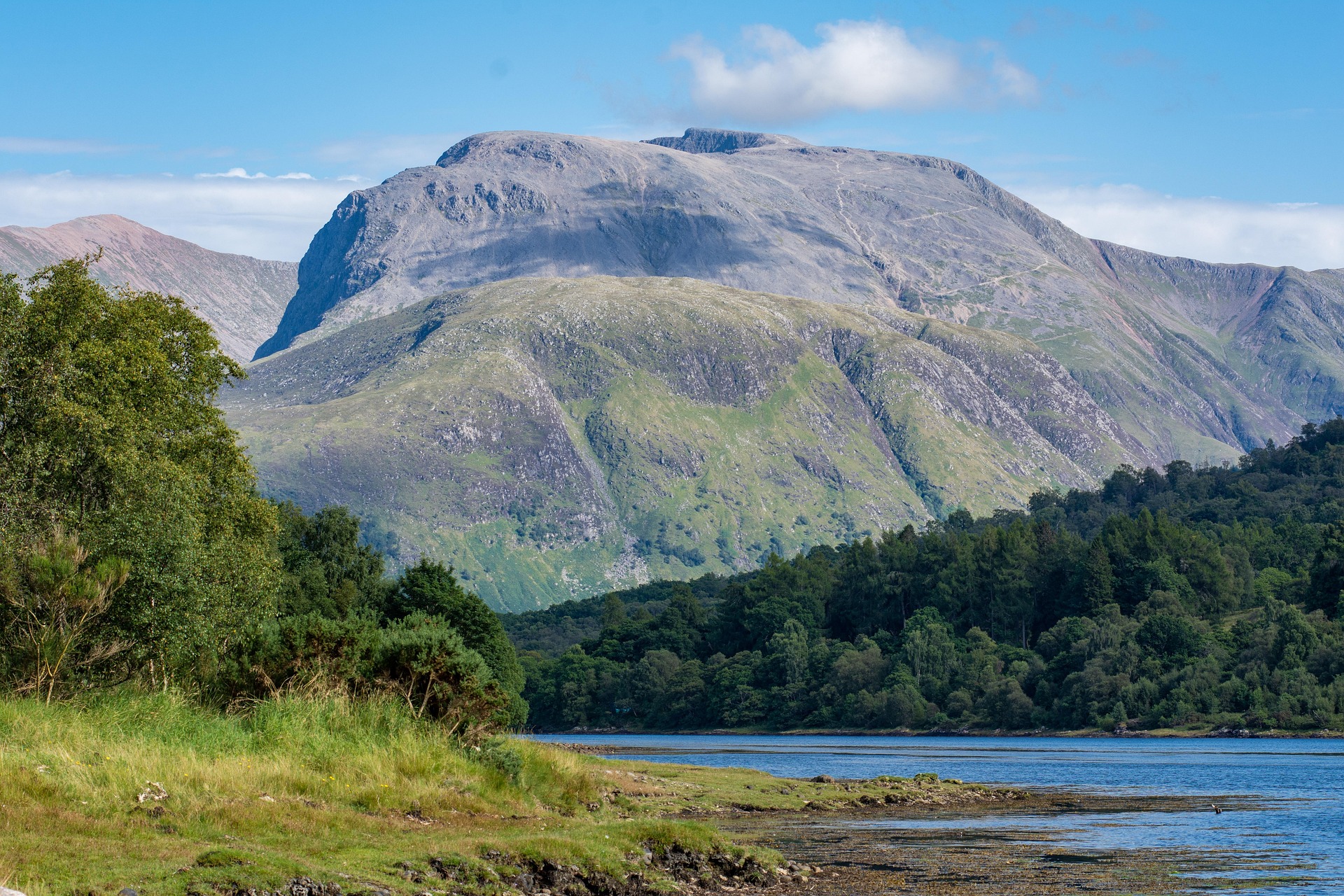
The Ben Nevis Scotland mountain is the highest peak in Scotland, Great Britain and the British Isles. It rises 1,345 metres (4,413 feet) above sea level in Lochaber, in the Scottish Highlands, close to Fort William.
Most visitors walk it by the Mountain Track from Glen Nevis. That path needs no technical climbing in normal summer conditions, but it is long, steep and exposed to fast-changing weather. This guide gives you the height and location answers first, then covers the route, preparation and safety.
Ben Nevis at a glance
| Fact | Detail |
|---|---|
| Location | Lochaber, Scottish Highlands, close to Fort William |
| Height | 1,345 metres (about 4,413 feet) |
| Range | Western end of the Grampian Mountains |
| Classification | Munro |
| Standard route | Mountain Track, also called the Pony Track or Tourist Route |
| Start point | Ben Nevis Visitor Centre, Glen Nevis |
| Distance | About 16 km (10 miles) return |
| Typical time | Roughly 6 to 9 hours return |
| Status | Highest mountain in Scotland, Great Britain and the British Isles |
Where is Ben Nevis located?
Ben Nevis is in Lochaber, in the Highland council area of Scotland. It sits to the south-east of Fort William, above the head of Glen Nevis, and forms the western end of the Grampian Mountains.
Fort William is the practical base for most visitors. The town has the accommodation, shops and transport links, and the walking route starts in Glen Nevis, a short distance away. From the glen, the mountain looks like a broad dome. The north-east side is very different, with huge cliffs that attract climbers and mountaineers.
How high is Ben Nevis in Scotland?
Ben Nevis is 1,345 metres (4,413 feet) high. That is the official Ordnance Survey figure, and it makes Ben Nevis the highest point in Scotland and the United Kingdom.
The number comes from a GPS survey at the summit. Ordnance Survey measured the highest natural point at 1,344.527 metres and rounded it up to 1,345 metres. The older figure of 1,344 metres dated from a 1949 survey. The mountain didn't grow. The newer equipment is simply more accurate.
Ben Nevis height versus the height you walk
The summit elevation is not the same as the amount you climb. The Mountain Track starts in the glen, close to sea level, and involves around 1,300 metres of ascent. The walk is also about 16 km return over rough ground, which is why the day takes so long.
Why Ben Nevis matters
Britain's highest mountain
As the highest summit in the British Isles, Ben Nevis draws first-time hillwalkers and Munro baggers alike. A Munro is a Scottish mountain over 3,000 feet, and Ben Nevis is the best known on the list.
The remains of a volcano
The mountain formed from the remains of a large volcanic system from the Devonian period. The summit and the great cliffs on the north side reflect the geology of that collapsed volcano.
The summit observatory
A weather observatory operated on the summit from the late nineteenth century into the early twentieth. The Mountain Track was built in that period to reach it, which explains the wide, graded line of the lower path.
The Gaelic name
The Gaelic name is Beinn Nibheis. It is commonly translated as "mountain with its head in the clouds" or "venomous mountain", though the origin of the name is debated.
Walking Ben Nevis: the Mountain Track
The Mountain Track is the easiest standard route to the summit, and VisitScotland's Ben Nevis guide points beginners to it. Easiest still means a strenuous mountain walk. The path climbs steadily in zigzags, then crosses rougher, rockier ground on the upper mountain and finishes on a wide, stony summit plateau.
The route in stages
| Stage | What to expect |
|---|---|
| Glen Nevis start | Check the forecast, your kit and your timing before you leave the car park. |
| Lower slopes | The path climbs at a manageable gradient, so keep an easy pace. |
| Middle section | The climb becomes more sustained and the surface rougher. |
| Upper mountain | Loose rock and boulders are common. Cloud and lying snow can reduce visibility. |
| Summit plateau | The ground is flat, featureless and close to steep cliffs. Navigate with care. |
Is this walk right for you?
Difficulty depends on fitness, hillwalking experience, weather, pack weight and pace. Ask yourself these questions before you commit:
- Can you stay active outdoors for 6 to 9 hours?
- Can you climb about 1,300 metres over rough, rocky ground?
- Do you have waterproof clothing and proper walking boots?
- Can you navigate with a map and compass if cloud hides the path?
- Will you turn back if conditions worsen?
If you answer no to any of these, build up on smaller hills first, or choose one of the low-level alternatives below.
Technical routes: not for first-time walkers
Other routes exist, but they belong to experienced mountain users. The table shows how they differ from the Mountain Track.
| Route | Character | Who it suits |
|---|---|---|
| Mountain Track | Graded path from Glen Nevis, no technical climbing in summer | Fit walkers with mountain preparation |
| Carn Mòr Dearg Arête | Narrow ridge with scrambling, linking a second Munro | Experienced hillwalkers comfortable with exposure |
| North Face routes | Steep cliffs, gullies and serious climbing ground | Trained climbers and mountaineers |
Don't treat any of these as a quick alternative to the standard path.
Ben Nevis weather and the best time to go
The summit can be cold, windy and wet when Fort William is mild. Cloud and hill fog can remove visibility completely. Snow on the path changes the walk, and Walkhighlands' Ben Nevis route description is clear that any ascent with snow lying on the path needs winter equipment and skills.
| Season | Planning message |
|---|---|
| Spring | Conditions can stay wintry on the upper mountain. |
| Summer | Daylight is long, but the path is busy and the weather still changes fast. |
| Autumn | Days shorten and wind and rain increase, so plan conservatively. |
| Winter | Mountaineering conditions are possible and specialist skills may be required. |
Summer doesn't guarantee a snow-free or settled day. Check the Mountain Weather Information Service forecast for the West Highlands, which covers Ben Nevis, rather than relying on a town forecast.
What to carry
- Waterproof jacket and trousers
- Warm insulating layers, a hat and gloves
- Sturdy walking boots with good grip
- Food, high-energy snacks and enough water
- Map and compass, and the skill to use them
- Charged phone and a power bank
- Headtorch, in case you return late
- First-aid kit and an emergency whistle
- Sun protection and sunglasses
Trainers, jeans and cotton clothing are poor choices for a long Scottish mountain walk. Pack extra layers, because the summit is much colder than the glen.
Safety on Ben Nevis
- Check the mountain forecast the morning you go.
- Start early so you finish in daylight.
- Tell someone your route and your expected return time.
- Stay on the main route near the summit and keep well away from cliff edges and gullies.
- Avoid paths that drift towards the North Face.
- Turn back if weather, tiredness or fading light makes the descent risky.
- In a genuine mountain emergency, call 999 or 112 and ask for Police.
The descent needs particular attention. Walkhighlands notes that fatalities have occurred when walkers trying to avoid the North Face steered too far south and fell into a gully. Five Finger Gully is one of the hazards near the summit, so follow the correct bearing in poor visibility.
Getting to Ben Nevis and visitor information
Drive or travel from Fort William into Glen Nevis to reach the Ben Nevis Visitor Centre, where the Mountain Track begins. The centre is a useful first stop for walking advice and weather updates, and it holds exhibits on local history.
Parking at the visitor centre is charged, and arrangements, prices and opening times can change. Check current details with local providers before you travel, along with any bus or taxi options from Fort William.
Things to do near Ben Nevis without climbing it
Plenty of Lochaber is open to visitors who skip the summit:
- Low-level walks in Glen Nevis, through forest, gorge and riverside
- The walk to Steall Falls through Nevis Gorge
- Fort William, for food, shops and local history
- Other Lochaber attractions, including the Jacobite steam train area and the local mountain gondola, subject to current operating information
Plan your Ben Nevis day
Check the latest mountain forecast, confirm access and parking details, and work out your turnaround time before you set off. A sensible plan matters more than the summit photo.